|
Chapter XIX
With Faces turned Homeward
First Across the Continent; The Story of The Exploring Edition of Lewis and Clark in 1804-5-6 | ||
19.
Chapter XIX
With Faces turned Homeward
THE officers of the expedition had decided to begin their homeward march on the first of April; but a natural impatience induced them to start a little earlier, and, as a matter of record, it may be said that they evacuated Fort Clatsop on the 23d of March, 1806. An examination of their stock of ammunition showed that they had on hand a supply of powder amply sufficient for their needs when travelling the three thousand miles of wilderness in which their sole reliance for food must be the game to be killed. The powder was kept in leaden canisters, and these, when empty, were used for making balls for muskets and rifles. Three bushels of salt were collected for their use on the homeward journey.
What they needed now most of all was an assortment of small wares and trinkets with which to trade with the Indians among whom they must spend so many months before reaching civilization again. They had ample letters of credit from the Government at Washington, and if they had met with white traders on the seacoast, they could have bought anything that money would buy. They had spent nearly all their stock in coming across the continent. This is Captain Lewis's summary of the goods on hand just before leaving Fort Clatsop:—
"All the small merchandise we possess might be tied up in a couple of handkerchiefs. The rest of our stock in
One of their last acts was to draw up a full list of the members of the party, and, making several copies of it, to leave these among the friendly Indians with instructions to give a paper to the first white men who should arrive in the country. On the back of the paper was traced the track by which the explorers had come and that by which they expected to return. This is a copy of one of these important documents:—
"The object of this list is, that through the medium of some civilized person who may see the same, it may be made known to the informed world, that the party consisting of the persons whose names are hereunto annexed, and who were sent out by the government of the U'States in May, 1804, to explore the interior of the Continent of North America, did penetrate the same by way of the Missouri and Columbia Rivers, to the discharge of the latter into the Pacific Ocean, where they arrived on the 14th of November, 1805, and from whence they departed the 23d day of March, 1806, on their return to the United States by the same rout they had come out."
Curiously enough, one of these papers did finally reach the United States. During the summer of 1806, the brig "Lydia," Captain Hill, entered the Columbia for the purpose of trading with the natives. From one of these Captain Hill secured the paper, which he took to Canton,
Fort Clatsop, as they called the rude collection of huts in which they had burrowed all winter, with its rude furniture and shelters, was formally given to Comowool, the Clatsop chief who had been so kind to the party. Doubtless the crafty savage had had his eye on this establishment, knowing that it was to be abandoned in the spring.
The voyagers left Fort Clatsop about one o'clock in the day, and, after making sixteen miles up the river, camped for the night. Next day, they reached an Indian village where they purchased "some wappatoo and a dog for the invalids." They still had several men on the sick list in consequence of the hard fare of the winter. The weather was cold and wet, and wood for fuel was difficult to obtain. In a few days they found themselves among their old friends, the Skilloots, who had lately been at war with the Chinooks. There was no direct intercourse between the two nations as yet, but the Chinooks traded with the Clatsops and Wahkiacums, and these in turn traded with the Skilloots, and in this way the two hostile tribes exchanged the articles which they had for those which they desired. The journal has this to say about the game of an island on which the explorers tarried for a day or two, in order to dry their goods and mend their canoes:—
"This island, which has received from the Indians the appropriate name of Elalah [Elallah], or Deer Island, is surrounded on the water-side by an abundant growth of cottonwood, ash, and willow, while the interior consists chiefly of prairies interspersed with ponds. These afford refuge to great numbers of geese, ducks, large swan, sandhill cranes, a few canvas-backed ducks, and particularly
The vulture here referred to is better known as the California condor, a great bird of prey which is now so nearly extinct that few specimens are ever seen, and the eggs command a great price from those who make collections of such objects. A condor killed by one of the hunters of the Lewis and Clark expedition measured nine feet and six inches from tip to tip of its wings, three feet and ten inches from the point of the bill to the end of the tail, and six inches and a half from the back of the head to the tip of the beak. Very few of the condors of the Andes are much larger than this, though one measuring eleven feet from tip to tip has been reported.
While camped at Quicksand, or Sandy River, the party learned that food supplies up the Columbia were scarce. The journal says that the Indians met here were descending the river in search of food. It adds:—
"They told us, that they lived at the Great Rapids; but that the scarcity of provisions there had induced them to come down, in the hopes of finding subsistence in the more fertile valley. All the people living at the Rapids, as well as the nations above them, were in much distress for want of food, having consumed their winter store of dried fish, and not expecting the return of the salmon before the next full moon, which would be on the second of May: this information
On the third of April this entry is made:—
"A considerable number of Indians crowded about us to-day, many of whom came from the upper part of the river. These poor wretches confirm the reports of scarcity among the nations above; which, indeed, their appearance
"In the evening Captain Clark returned from an excursion. On setting out yesterday at half-past eleven o'clock, he directed his course along the south side of the [Columbia] river, where, at the distance of eight miles, he passed a village of the Nechacohee tribe, belonging to the Eloot nation. The village itself is small, and being situated behind Diamond Island, was concealed from our view as we passed both times along the northern shore. He continued till three o'clock, when he landed at the single house already mentioned as the only remains of a village of twenty-four straw huts. Along the shore were great numbers of small canoes for gathering wappatoo, which were left by the Shahalas, who visit the place annually. The present inhabitants of the house are part of the Neerchokioo tribe of the same [Shahala] nation. On entering one of the apartments of the house, Captain Clark offered several articles to the Indians in exchange for wappatoo; but they appeared sullen and ill-humored, and refused to give him any. He therefore sat down by the fire opposite the men, and taking a port-fire match from his pocket, threw a small piece of it into the flame; at the same time he took his pocket-compass, and by means of a magnet, which happened to be in his inkhorn, made the needle turn round very briskly. The match now took fire and burned violently, on which the Indians, terrified at this strange exhibition, immediately brought a quantity of wappatoo and laid it at his feet, begging him to put out the bad fire, while an old woman continued to speak with great vehemence, as if praying and imploring protection. Having received the roots, Captain Clark put up the compass,
The excursion from which Captain Clark had returned, as noted in this extract, was up the Multnomah River. As we have already seen, the explorers missed that stream when they came down the Columbia; and they had now passed it again unnoticed, owing to the number of straggling islands that hide its junction with the Columbia. Convinced that a considerable river must drain the region to the south, Captain Clark went back alone and penetrating the intricate channels among the islands, found the mouth of the Multnomah, now better known as the Willamette. He was surprised to find that the depth of water in the river was so great that large vessels might enter it. He would have been much more surprised if he had been told that a large city, the largest in Oregon, would some day be built on the site of the Indian huts which he saw. Here Captain Clark found a house occupied by several families of the Neechecolee nation. Their mansion was two hundred and twenty-six feet long and was divided into apartments thirty feet square.
The most important point in this region of the Columbia was named Wappatoo Island by the explorers. This is a large extent of country lying between the Willamette and an arm of the Columbia which they called Wappatoo Inlet, but which is now known as Willamette Slough. It is twenty miles long and from five to ten miles wide. Here is an interesting description of the manner of gathering the roots of the wappatoo, of which we have heard so much in this region of country:—
"The chief wealth of this island consists of the numerous ponds in the interior, abounding with the common arrowhead (sagittaria sagittifolia) to the root of which is attached a bulb growing beneath it in the mud. This bulb, to which the Indians give the name of wappatoo,[1] is the great article of food, and almost the staple article of commerce on the Columbia. It is never out of season; so that at all times of the year the valley is frequented by the neighboring Indians who come to gather it. It is collected chiefly by the women, who employ for the purpose canoes from ten to fourteen feet in length, about two feet wide and nine inches deep, and tapering from the middle, where they are about twenty inches wide. They are sufficient to contain a single person and several bushels of roots, yet so very light that a woman can carry them with ease. She takes one of these canoes into a pond where the water is as high as the breast, and by means of her toes separates from the root this bulb, which on being freed from the mud rises immediately to the surface of the water, and is thrown into the canoe. In this manner these patient females remain in the water for several hours, even in the depth of winter. This plant is found through the whole extent of the valley in which we now are, but does not grow on the Columbia farther eastward."
The natives of this inland region, the explorers found, were larger and better-shaped than those of the sea-coast, but they were nearly all afflicted with sore eyes. The loss of one eye was common, and not infrequently total blindness was observed in men of mature years, while blindness was almost universal among the old people. The white men made good use of the eye-water which was among their supplies; it was gratefully received by the natives and won them friends among the people they met. On the fifth of April the journal has this entry:—
"In the course of his chase yesterday, one of our men [Collins], who had killed a bear, found the den of another with three cubs in it. He returned to-day in hopes of finding her, but brought only the cubs, without being able to see the dam; and on this occasion Drewyer, our most experienced huntsman, assured us that he had never known a single instance where a female bear, which had once been disturbed by a hunter and obliged to leave her young, returned to them again. The young bears were sold for wappatoo to some of the many Indians who visited us in parties during the day and behaved very well."
And on the ninth is this entry:—
"The wind having moderated, we reloaded the canoes and set out by seven o'clock. We stopped to take up the two hunters who left us yesterday, but were unsuccessful in the chase, and then proceeded to the Wahclellah village, situated on the north side of the river, about a mile below Beacon Rock. During the whole of the route from camp we passed along under high, steep, and rocky sides of the mountains, which now close on each side of the river, forming stupendous precipices, covered with fir and white cedar. Down these heights frequently descend the most beautiful cascades, one of which, a large creek, throws itself over a perpendicular rock three hundred feet above the water, while other smaller streams precipitate themselves from a still greater elevation, and evaporating in a mist, collect again and form a second cascade before they reach the bottom of the rocks. We stopped to breakfast at this village. We here found the tomahawk which had been stolen from us on the fourth of last November. They assured us they had bought it of the Indians below; but as the latter had already informed us that the Wahclellahs
The Columbia along the region through which the expedition was now passing is a very wild and picturesque stream. The banks are high and rocky, and some of the precipices to which the journal refers are of a vast perpendicular height. On the Oregon side of the river are five cascades such as those which the journal mentions. The most famous and beautiful of these is known as Multnomah Falls. This cataract has a total fall of more than six hundred feet, divided into two sections. The other cascades are the Bridal Veil, the Horsetail, the Latourelle, and the Oneonta, and all are within a few miles of each other.
On the ninth of April the voyagers reached the point at which they were to leave tidewater, fifty-six miles above the mouth of the Multnomah, or Willamette. They were now at the entrance of the great rapids which are known as the Cascades of the Columbia, and which occupy a space on the river about equal to four miles and a half. They were still navigating the stream with their canoes, camping sometimes on the north side and sometimes on the south side of the river. This time they camped on the north side, and during the night lost one of their boats, which got loose and drifted down to the next village of the Wahclellahs, some of whom brought it back to the white men's camp and were rewarded for their honesty by a present of two knives. It was found necessary to make a portage here, but a long and severe rainstorm set in, and the tents and the skins used for protecting the baggage were soaked. The journal goes on with the narrative thus:—
We determined to take the canoes first over the portage,
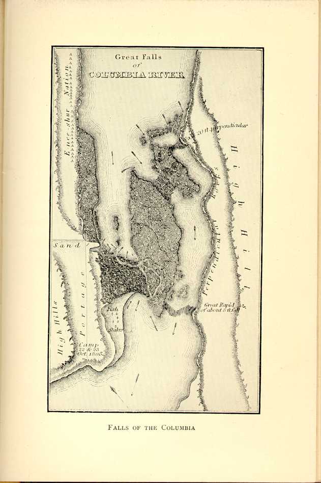
FALLS OF THE COLUMBIA
[Description: Map of a portion of the Columbia River showing current directions and fall and rapid locations. ]"We now found it necessary to depart from our mild and pacific course of conduct. On returning to the head of the portage, many of them met our men and seemed very ill-disposed. Shields had stopped to purchase a dog, and being separated from the rest of the party, two Indians pushed him out of the road, and attempted to take the dog from him. He had no weapon but a long knife, with which he immediately attacked them both, hoping to put them to death before they had time to draw their arrows; but as soon as they saw his design they fled into the woods. Soon afterward we were told by an Indian who spoke Clatsop, which we had ourselves learned during the winter, that the Wahclellahs had carried off Captain Lewis' dog to their village below. Three men well armed were instantly despatched in pursuit of them, with orders to fire if there was the slightest resistance or hesitation. At the distance of two miles they came within sight of the thieves,
"We were visited during the day by a chief of the Clahclellahs, who seemed mortified at the behavior of the Indians, and told us that the persons at the head of their outrages were two very bad men who belonged to the Wahclellah tribe, but that the nation did not by any means wish to displease us. This chief seemed very well-disposed, and we had every reason to believe was much respected by the neighboring Indians. We therefore gave him a small medal and showed him all the attention in our power, with which he appeared very much gratified."
The portage of these rapids was very difficult and tiresome. The total distance of the first stage was twenty-eight hundred yards along a narrow way rough with rocks and now slippery with rain. One of the canoes was lost here by being driven out into the strong current, where the force of the water was so great that it could not be held by the men; the frail skiff drifted down the rapids and disappeared. They now had two canoes and two periogues left, and the loads were divided among these craft. This increased the difficulties of navigation, and Captain Lewis crossed over to the south side of the river in search of canoes to be purchased from the Indians, who lived in a village on that side of the stream. The narrative continues:
"The village now consisted of eleven houses, crowded with inhabitants, and about sixty fighting men. They were very well disposed, and we found no difficulty in procuring two small canoes, in exchange for two robes and four elk-skins.
Above the rapids the party encountered two tribes of Indians from whom they endeavored to buy horses, for they were now approaching a point when they must leave the river and travel altogether by land. One of these tribes was known as the Weocksockwillacurns, and the other was the Chilluckittequaws. These jaw-breaking names are commended to those who think that the Indian names of northern Maine are difficult to handle. Trees were now growing scarcer, and the wide lowlands spread out before the explorers stretched to the base of the Bitter Root Mountains without trees, but covered with luxuriant grass and herbage. After being confined so long to the thick forests and mountains of the seacoast, the party found this prospect very exhilarating, notwithstanding the absence of forests and thickets. The climate, too, was much more agreeable than that to which they had lately been accustomed, being dry and pure.
|
Chapter XIX
With Faces turned Homeward
First Across the Continent; The Story of The Exploring Edition of Lewis and Clark in 1804-5-6 | ||